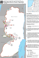
From MESH  "This map, by the UN Office for the Coordination of Humanitarian Affairs, provides an update on the status of Israel’s West Bank barrier, showing segments completed, under construction, and planned, as of July 2008. The barrier’s total length is now projected to be 723 kilometers, more than twice the length of the 1949 Armistice Line (Green Line) between the West Bank and Israel. The total area located between the barrier and the Green Line is 9.8 percent of the West Bank (including East Jerusalem and the pre-1967 No Man’s Land enclave).
The map projects the numbers and identifies locations of four groups of Palestinians whose access to the rest of the West Bank may be affected by the barrier. Two of these groups will be on the opposite side of the barrier from the West Bank:
- Approximately 35,000 Palestinians with West Bank identity cards will be located between the barrier and the Green Line.
- The majority of the 250,000 Palestinians with East Jerusalem identity cards will reside between the barrier and the Green Line.
The other two groups will have fewer or less direct means of access to the West Bank than in the past:
- Approximately 26,000 Palestinians in two enclaves will be surrounded entirely by the barrier, and their access to the rest of the West Bank will be by tunnel or road connection.
- Approximately 125,000 Palestinians will be surrounded by the barrier on three sides.
No comments:
Post a Comment